37
Tecnología y Ciencias del Agua
, vol. VIII, núm. 2, marzo-abril de 2017, pp. 31-41
Li
et al
.,
Particle size distribution and settling velocity of sediments in water diverted from the Yellow River during border-strip irrigation
ISSN 2007-2422
•
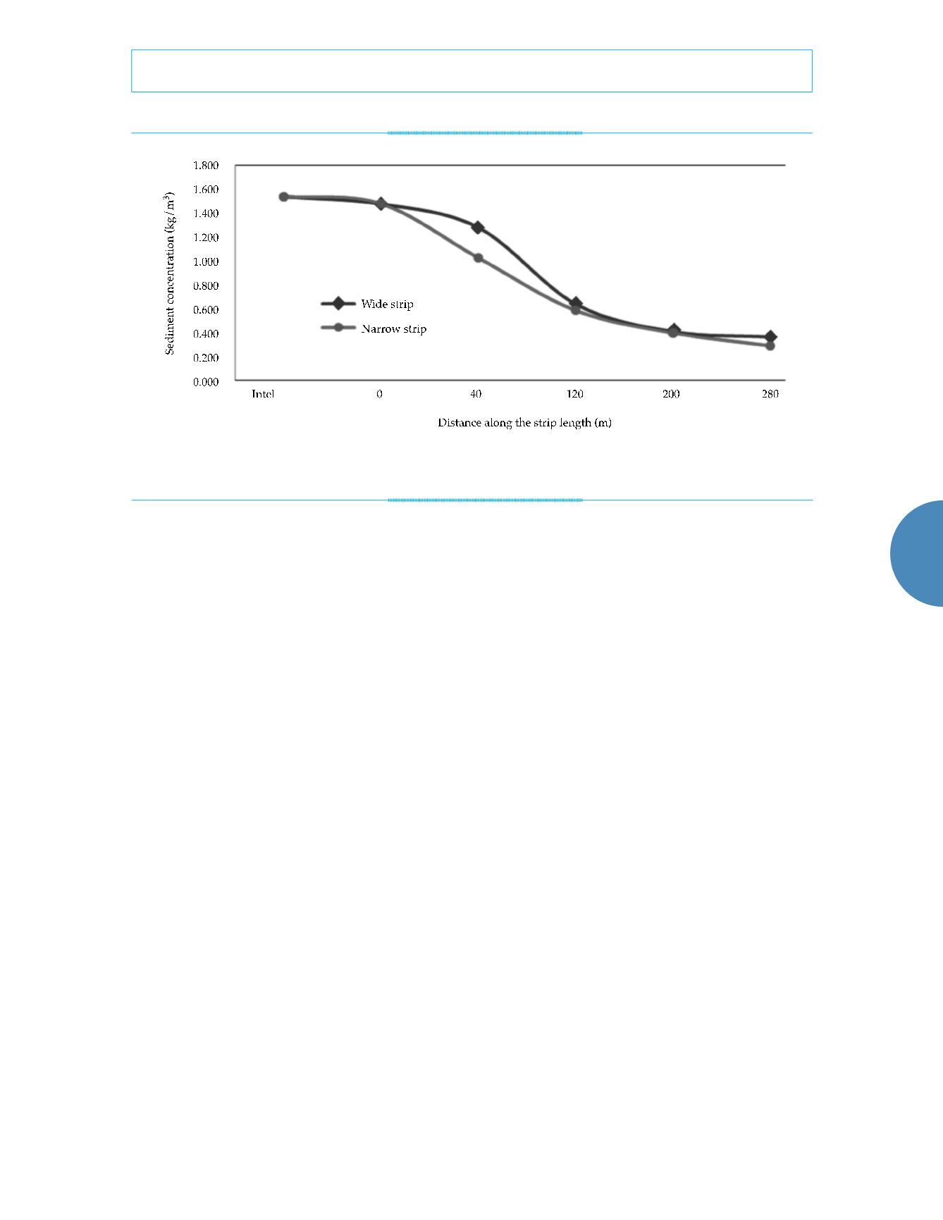
result that the sediment concentrations were
significantly higher at the top ends of the strips
than at the bottom ends. The decrease in sedi-
ment concentration was sharp over the 0 to 120
m section of each strip, while it was relatively
slower over the 120 to 180 m section, indicating
that the majority of the sediment carried by the
irrigation water settled at the top ends of the
strips. This pattern of variation was especially
marked on the narrow strip, a finding that can
possibly be attributed to the higher flow rate
and thus the higher sediment concentration in
the irrigation water at the top end of the narrow
strip.
Particle size distribution of sediment in
water flow over the strips
Figures 5 and 6 show that the particle sizes class
of sediments carried by the irrigation water
largely fell within the range of 0.004 to 0.016
mm, while coarse and fine particles accounted
for only small fractions of the sediments. The
concentration of coarse particles was higher
at the top ends of the strips than at the bottom
ends, while the concentration of fine particles
was higher at the bottom ends than at the top
ends. This suggests that coarse particles settled
out of the fluid earlier than fine particles, with
the result that the slower-settling fine particles
advanced further with the water flow. The ir-
rigation water at the bottom ends contained
more sediment particles ranging from 0.001 to
0.008 mm in size than the water at the top ends,
because parts of the surface sediment that had
settled on the strips were scoured away by the
moving water. Further analysis and research
is needed to find out why particles in this size
range were mobilized by the water flow.
Figure 7 shows the variations in soil water
content before and after irrigation at three
monitoring points on each strip, located at the
top end, middle section, and bottom end. Before
irrigation, the water content in the topsoil was
about 20%, indicating a need for irrigation.
Meanwhile, soil deeper than 60 cm varied
slightly in water content, roughly around 23%.
On the first and second days after irrigation, the
topsoil exhibited marked increases in water con-
tent. At the three monitoring points, the overall
soil water content on the first day after irriga-
tion was very close to the water content on the
second day after irrigation. The topsoil’s water
content increased more than 5% compared to
the level before irrigation, and the deeper layers
also demonstrated noticeable increases in water
Figure 4. Distribution of sediment concentration along the strip length.


